NOTICE
NYPAD updated version now available.
Web service links for NYPAD have changed.
The latest version of NYPAD is available for download and through a new set of feature service links. Go to the Download Data tab and fill in our user survey to get an email with download information and with the new feature service links.
Thanks!
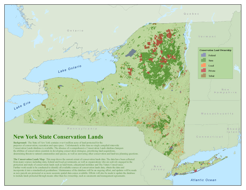
Background:
NYPAD is a spatial database of lands protected or designated as natural areas, conservation lands, open space, or recreational areas. These lands cover over five million acres, approximately 20% of New York State. While the database has ‘Protected’ in its name, we use that term broadly. Lands in NYPAD may be public or private, open or closed to public use, permanently protected from development or subject to future changes in management.
Not all lands in NYPAD are open to the public -- "protected" is not the same as "open". Inclusion in NYPAD does not imply permission for the public to enter that area – many lands in NYPAD are not publicly accessible. Assume any protected area included in NYPAD is closed to the public until you verify it is open by contacting the managing organization or consulting their website for information on public access and other rules regarding use of the area.
The data in NYPAD can be viewed in the interactive map, or downloaded for use with a GIS or another mapping application. Limited attribute information about an area is available in the interactive map. Full attribute information is available in the downloaded data.
NYPAD is an ever-evolving database. Early versions will include publicly owned lands open to the public, such as municipal parks and playgrounds; State Forests, Forest Preserve lands, Wildlife Management Areas, and State Parks; and National Recreation Areas, National Seashores, and National Forests. Preserves of The Nature Conservancy will also be in early versions of NYPAD. Later versions will add lands owned or under conservation easement by land trusts and other private organizations, lands under conservation easement by New York State, forest lands registered under New York State’s 480-a program, and more.
Data on protected areas have been collected from state, federal, and local governments; private conservation organizations and land trusts; and colleges and universities. Efforts to identify other sources of protected area data, and to obtain the data and incorporate it into NYPAD’s geodatabase, are ongoing. Maintenance of the data is also ongoing; updates will be made as new parcels are protected and as more accurate spatial data becomes available.
NYPAD is a project of the New York Natural Heritage Program, a partnership between the State University of New York College of Environmental Science and Forestry and New York State Department of Environmental Conservation. Collaborators include The Nature Conservancy, Scenic Hudson, and New York State Office of Parks, Recreation and Historic Preservation.
New York Protected Areas Map:This map shows the protected lands in New York State currently included in NYPAD. |
|